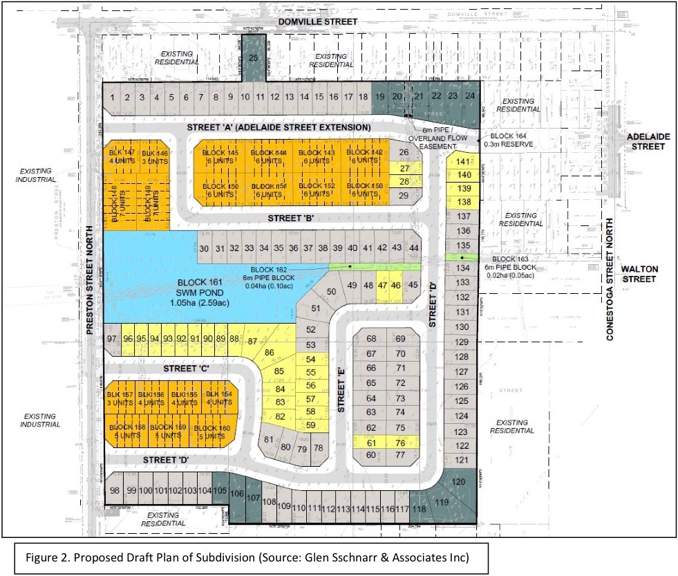
WELLINGTON NORTH – Local residents expressed concerns about stormwater management and environmental impacts during a Nov. 23 public meeting on a proposed 240-unit subdivision in Arthur.
Cachet Developments Inc. is seeking approval for a draft plan of subdivision that includes 141 detached homes and 99 townhouse units.
The 11.2-hectare property is bounded by Domville Street to the north, Smith Street to the south, and Preston Street North and Conestoga Street North to the east and west respectively.
The applicant is also seeking to rezone the lands from high density residential holding zone, low density and medium density residential to site specific low density residential zone and high density residential zone (R3-xx).
Through the process, the applicant is seeking to remove the Holding symbol on the lands, which is in place to ensure the availability of sufficient municipal service capacity.
“We are not the decision making authority in terms of the plan of subdivision,” Mayor Andy Lennox pointed out during the video conference meeting.
“We are the decision making authority with regard to the zoning bylaw amendments which may come out of the plan of subdivision.”
Lennox said the purpose of the meeting is to collect information for the County of Wellington and “ask questions, make suggestions to the developer.”
Wellington County manager of planning and environment Linda Redmond noted the requested zoning “is pretty much the same as what’s on the site,” with some requested relief from frontage and setback requirements on some of the lots.
She also noted the proposed development is within the built boundaries of the village of Arthur.
“That’s important to note because you want 20 per cent of your development occurring within that built boundary,” she explained.
Redmond noted an existing draft plan of subdivision on the site was created in 1993 and contains a large school block, which is no longer required due to subsequent school construction elsewhere in Arthur.
“That’s a big reason for this new plan that’s coming forward, as clearly those lands can be developed with something else,” Redmond pointed out.
She also noted the old plan doesn’t properly address storm water management, while the new one includes a stormwater management pond.
Redmond said most of the comments and concerns expressed in submissions by local residents were related to “the drainage of the land and potential flooding of the neighbouring properties once the development moves forward,” as well as “some concerns with the density of the proposed plan.”
Stephen Closs, a planning consultant with Glen Schnarr and Associates, acting for the developer, pointed out the site of the proposed subdivision is “one of the largest pieces of undeveloped land within Arthur.”
Closs noted the plan calls for five new internal streets and the upgrading of Preston Street North to asphalt, with sidewalks planned for the east side.
“The compact nature and the location of the proposed subdivision means that the new homes will be within walking distance from schools, from Arthur’s downtown and from the employer (Musashi Auto Parts Canada) to the west,” said Closs.
He also said the development represents a “prime opportunity to assist the county in meeting its growth targets,” including a projected population increase of about 35 per cent, or 945 people, in Arthur by 2041.
Conestoga Street residents Lynda and George White expressed concern about potential flooding related to the development.
“We can’t say we don’t get these hundred-year storms anymore,” said Lynda, pointing out that “last year our lawn was under water.”
She continued, “We just want to make sure the water issues are addressed and we aren’t going to end up getting flooded out every year because of this new subdivision.”
Closs responded that drainage studies indicate the development “won’t create any new upstream issues from the subject lands.”
“Given the location … and the topography of it, we really have to make sure this is right before we can proceed. Your concerns, certainly I hear them loud and clear,” Lennox told the Whites.
Local resident Mike DeWitt said, “I look at all this residential zoning and I never see any green land set aside for that natural aspect that should be part of every bit of town I think.”
He asked, “Why do we always have to destroy everything for the sake of a couple of extra houses? I think the development is going to come regardless, but could we not set something aside for the wildlife as well?”
Another local resident, Brent McKee, pointed out the bush lot is home to a number of deer and other wildlife.
Closs replied, “I recognize there may be wildlife on that lot. But the truth is that it is zoned residential.
“We have prepared an environmental impact statement which is going to be reviewed by the Grand River Conservation Authority, so ecological impacts will be mitigated as much as possible.
“But it is land that’s targeted for residential development ultimately.”
Lennox and councillor Steve McCabe both asked about the density of the proposed development in comparison to provincial standards.
Redmond explained the province requires 16 units per hectare (6.5 per acre) and the development will reach 21.39 units per hectare.
“They exceed the density target,” she stated.
Cachet Homes planner Marcus Gagliardi said the development would be completed in phases, based partly on the availability of sewage capacity.
Wellington North CAO Mike Givens pointed out phasing of the development could be regulated through the number of building permits issued in a given year.


