Proposal for new subdivision on Gerrie Road returns to council


ELORA – A proposal for a subdivision on a parcel of land along the Salem-Elora urban boundary has returned to council after first being presented in 2019.
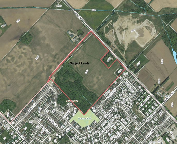
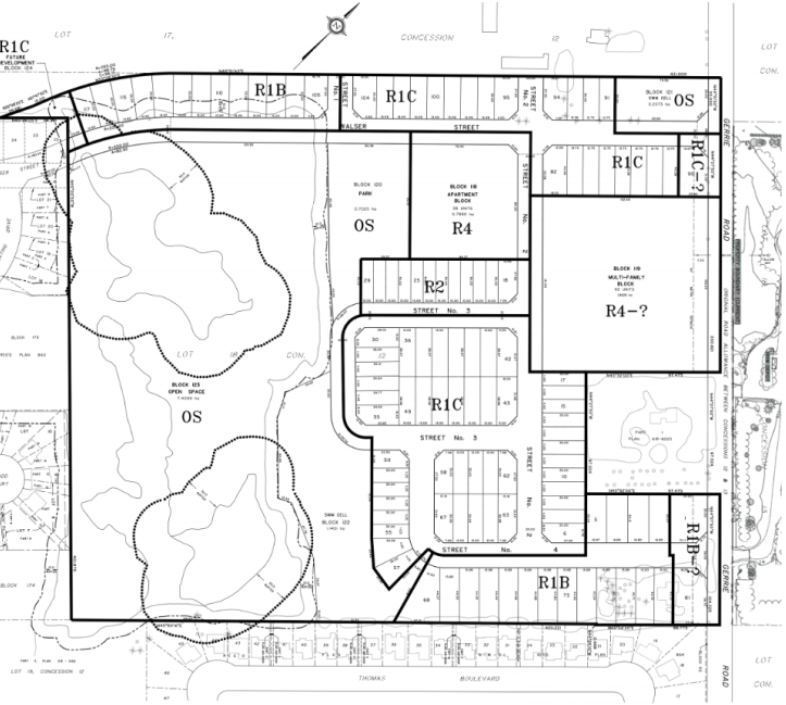
Centre Wellington council held a public meeting on Jan. 27 about a proposal to build 241 units of mixed housing on a 21.46-hectare (50-acre) piece of property at 6542 and 6560 Gerrie Road, northeast of Elora near the Elora Transfer Station.
The proposal includes an apartment building, cluster townhouses, and single-detached homes, as well as parks, open space, storm water management ponds and walkways.
Keating Construction is the owner and developer of the property and is seeking a zoning change, from agricultural and environmental protection to residential, open space, future development and environmental protection.
The property includes a woodlot and locally significant wetlands that, together with the open space and stormwater management lands, comprise about 44 per cent of the property. Tom Keating is proposing to give that piece to the township as dedicated parkland.
When complete, the development be a compact community that protects the natural heritage and links Irvine Street and Gerrie Road by extending Walser Street, said Nancy Shoemaker, the planning consultant hired by Keating, as she updated council and delegates at the meeting.
“We have tried to create a plan that is sensitive to adjacent land uses. We have considered that,” Shoemaker said.
She noted the proposal has been amended to include additional buffering between the location of townhouses and existing neighbours, including a heritage home on Gerrie Road.
Fred Gordon owns that home, which is called Bachelor Hall and was built by the Gerrie family about 190 years ago.
Gordon said the house “may be the first stone structure north of the Grand River. It can be traced to earliest development” of the area.
Gordon was concerned about the transition between the new development and his historical property and the surrounding bucolic landscape.
“It lacks a transitional area between us and the subdivision,” he said.
“I’m asking for a study of fauna, monarch butterflies, and a heritage impact assessment. I want to work with the developer but protect the heritage landscape of Gerrie Road."
Later in the meeting, councillor Kirk McElwain asked whether the property needed a heritage impact assessment.
“If it was designated, then yes,” said senior township planner Mariana Iglesias, adding the house is listed on the heritage registry, which means it is protected from demolition – but it isn’t designated.
“That’s not to say the property doesn’t warrant designation. It could,” Iglesias said. “We could further study the heritage value.”
She explained the property was mentioned as the township is undertaking a cultural heritage landscape study, “and it was reviewed by the criteria … This was not identified in the short list. Given the comments raised though, I will take these comments to the consultant.”
Most of the other delegates at the meeting live on streets like Keating Drive and Thomas Blvd. that back onto the property.
They spoke of the wooded area that’s a favourite for families and dog-walkers, and the wetland, that attracts flora and fauna.
It’s common to see deer and a wide variety of birds; it’s on the migratory path of monarch butterflies; and sometimes even bears can be seen, the speakers said.
“There’s a sense of community in the woods that council should be aware of,” said Jeff Neely, a local resident.
“People look after the place, shovelling snow and clearing branches from the paths.”
As well as protecting those areas, delegates wanted to ensure that fencing wouldn’t be put up and thereby deny access to the areas or impact natural drainage.
David Tinker saw an opportunity to enhance active transportation routes and walking routes for children heading to school.
“The biggest thing for me is kids getting to school. There’s not much encouragement to walk,” he said.
Janet Harrop, president of the Wellington County Federation of Agriculture, spoke on behalf of her 1,400 members in opposition to the proposal.
“We recognize it is identified as future development, but with the loss of class A (agricultural) land, the WFA has to oppose this," she said.
"Once farmland is lost to housing, it is lost forever."
Council did not make a decision on the application; it will return to council at a later date.
If the zoning change application is approved, the project will move to site-specific details.