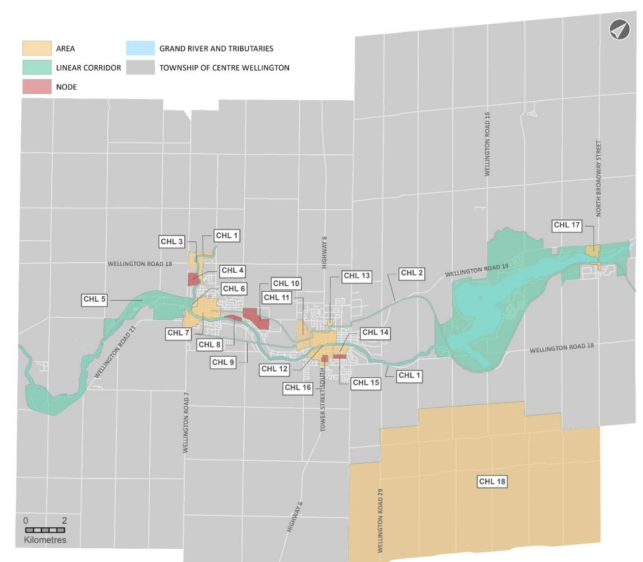
Eighteen cultural heritage landscapes identified in Centre Wellington


ELORA – Centre Wellington has identified 18 cultural heritage landscapes within its borders – areas that have historical, cultural and community value and should be protected from development.
Council heard a presentation by Kristina Martens and Annie Veilleux of ASI (Archaeological Services Inc.) at its special committee of the whole meeting on Nov. 30.
The presentation outlined how the areas were determined and the next steps.
Cultural heritage landscapes (CHLs) are different from heritage buildings or structures, though heritage and designated buildings can certainly be found within the identified CHLs.
With CHLs, “the whole is greater than the sum of its parts. They are valued together for their meaning.
“These special places are the hallmarks of the community,” Veilleux said.
[related]
In the past year, the ASI team conducted research and field visits, consulted with six Indigenous organizations, and held public open houses and mapping sessions to determine the CHLs.
Veilleux said the Grand River “influenced the movement of Indigenous and early settlers,” as did the physical geography of the area.
In the 19th century, surveyors laid down a grid pattern that determined roads and property boundaries and helped establish the villages of Fergus, Elora, Salem, Aboyne and Belwood.
Agriculture, manufacturing, the railway and industry also determined the growth and land use in the area.
The CHLs consider this rich history as well.
The 18 CHLs identified include:
- the Grand River corridor;
- the Elora Cataract Trailway;
- Salem;
- Elora Municipal and St. Mary’s R.C. Cemeteries;
- the Elora Gorge;
- Victoria Park and Victoria Crescent neighbourhood in Elora;
- Elora historical village core;
- the Elora Quarry;
- the Trestle Bridge Trail;
- the Allan Farmstead;
- Beatty Brothers factory and residential areas;
- Fergus historical village core;
- Churchill Crescent neighbourhood;
- Ferrier Estate and Union St. E.;
- Belsyde Cemetery;
- Victoria Park in Fergus;
- Belwood historical village core; and
- Oustic.
Veilleux said this was a preliminary report. What comes next are detailed studies and assessments of the CHLs and firming up boundaries.
For this work the team identified Salem, Victoria Park and Victoria Crescent neighbourhood, Elora historical village core, the Beatty Brothers factory and residential areas, Fergus historical village core, Churchill Crescent neighbourhood, Ferrier Estate and Union St. E, Belsyde Cemetery, and Victoria Park in Fergus as priorities as they are under threat of development.
“The rural areas can happen later,” she said. “There is less pressure of development.”
Councillor Kirk McElwain wanted to know if the CHL label affords any protection to the identified areas.
“This is a label,” Veilleux said. “There are different ways to approach protection. Some might just require commemoration. Some will require additional studies to develop protection measures."
“That will be our job,” said Mariana Iglesias, senior planner for Centre Wellington. “This is an evolving document.”
Iglesias said the priority areas could be added to the heritage registry.
“That gives them 60-day protection – especially those under threat of demolition,” she said.
Iglesias said she would return to council in the spring for an endorsement of the sites and implementation strategy.
“We’ll figure out the best approach for each landscape, funding and timelines,” she said.
Brett Salmon, managing director of planning and development, said funds for this project have been included in the 10-year forecast.
“Those of us who grew up here know these special places and why they are so special,” said Mayor Kelly Linton. “I’m excited about this.”
The public is invited to comment until Jan. 29.


